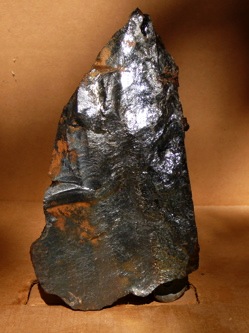
What is it? Who made it? How was it made? When? What is it worth?
In September 2007, archeologists digging near the intersection of Girard and Aramingo Avenues in Philadelphia uncovered this six-inch tall obsidian-like object. Research is underway but here are some tantalizing clues shared by neighborhood historians Torben Jenk and Ken Milano with the archeologists from URS, Douglas Mooney and Tony McNichol. Douglas Mooney is the President of the Philadelphia Archaeology Forum. They welcome citizens to "Explore Philadelphia's Hidden Past" with special activities and presentations each October.
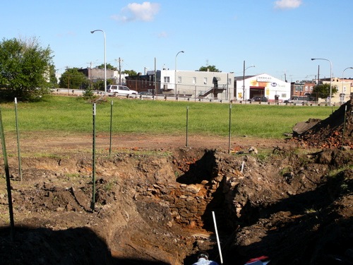
Three holes were dug in preparation for temporary ramps for the Girard Avenue interchange of I-95. Note the stone foundation. The "object" was retrieved with permission from the pile to the right. The silver SUV is heading northeast from Delaware Avenue to Aramingo Avenue. The dark SUV and pickup are heading southwest from Aramingo Avenue to southbound I-95 or Delaware Avenue. Norris Street is behind the silver SUV. The shadows in the foreground are cast by the connector ramp between Girard Avenue and Richmond Street.
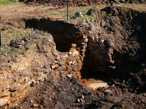
The basement seems contained to the left with the structure seemingly parallel to the Delaware River. Note the apparent buttress to the right which is not "keyed in" to the original stonework. That buttress could have provided structural support. Why would there have been foundation problems?
-----
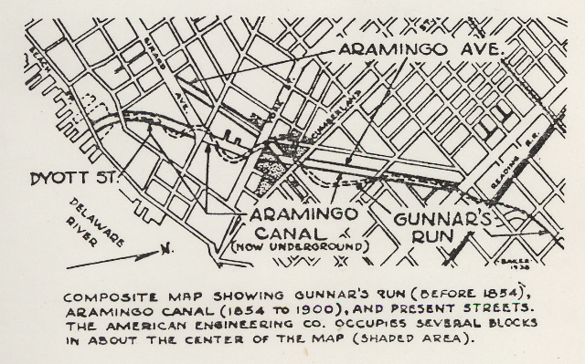
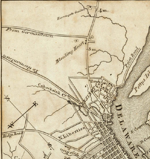
The September 2007 excavation is where the dotted lines wave at the end of Girard Avenue. Wholescale demolition and road realignments took place during the building of I-95. This map was drawn by George Baker to illustrate his story GUNNER'S RUN, published in "Our Affairs" [American Engineering Foremens Club, Vol 5, No 2, March 1938], which is reprinted here.
The girl on the phone had never heard of it, yet right behind her there still flows, silent and buried, waters that once were crowded with the romance of American industry. Searchers through Roman ruins can find but little more contrast between past and present than here on Aramingo Avenue.
Through sylvan fields there flowed a winding stream which the Indians called Tumanaraming. Years before Penn arrived, a Swede, Gunnar Rambo, had already settled here and given the stream his name. Later, it was corrupted into Gunner, and there is a homely tradition that it alludes to the sportsmen who once came gunning here for reed birds. Rising near what is now Broad above Lehigh it flowed east, until beyond Frankford Road, where it turned sharply southwest on about the line of Aramingo Avenue, and entered the Delaware above the present Norris Street.
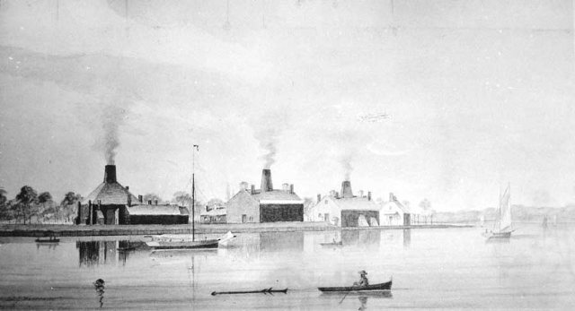
Here was one of the most comprehensive attempts at communal living. Established in 1771 and operating until 1900, the Dyottville Glass Works was, in 1830, the largest in the United States. Today, the only reminder is Dyott Street. But Dr. T. W. Dyott left his mark on the factory and educational systems of the whole country. Convinced that labor need not be degrading, he endeavored to improve the state of his men and equipment. To minimize unemployment, he redesigned his ovens to run for longer periods between repairs, and he started a campaign for temperance. One thing leading to another, he found himself with a complete community in which the prevalent pastimes of drinking, gambling, rioting, profane language and obscene songs were forbidden and in their place was a recreation room and field, with instructor, a school teaching the 3 R's, singing and flute playing a library and chapel. There were separate dormitories for single men, single women, and apprentice boys, and there were forty two-story brick dwellings to encourage ealrly marriage. There was also a hospital and apothecary and a complete set of shops such as blacksmith, bakery, tailor etc. as well as a 300 acre diversified farm making Dyottyille almost entirely self-sufficient.
Diversified learning, including farming, was encouraged so that apprentices would not be dependent on one trade alone. There was a grievance period, and restriction of privileges was used instead of corporeal punishment. Punishment was rare, because the employees realized the advantages of their little Utopia. Dr. Dyott, in a descriptive booklet of 1833, invited criticism, and got it. A Legislative Committee investigated and reported with warm praise.
There were 400 employees and 50 buildings, including 5 glass factories making vials, bottles, demijohns, etc. Some of the products may be seen today in Memorial Hall, Fairmount Park.
Yet in all his description, Dr. Dyott does not once mention Gunners Run, or Creek, although in 1851 Thomas Pernon wrote "In the old time it was quite a large stream, and large sloops were launched near a mile from its mouth."
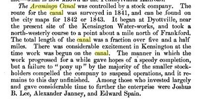
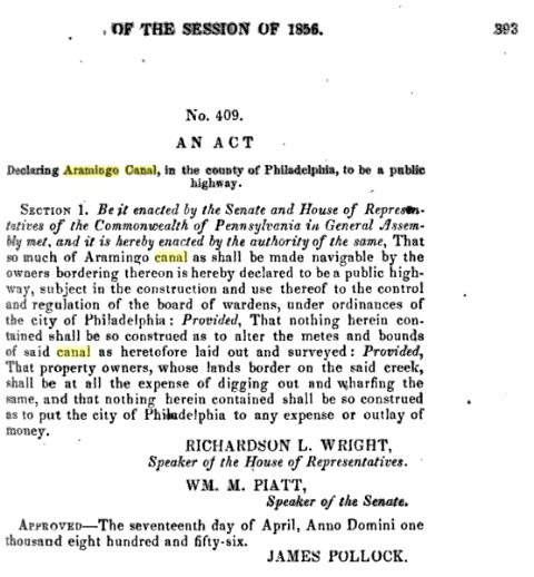
"Canal Fever" swept the country in the first half of the 19th century, and the Kensington and Richmond residents were caught by the golden miasma. Chartered in 1847, the Gunner's Run Improvement Company built the Aramingo Canal on a line now followed by Aramingo Avenue from Lehigh to Cumberland, from there straight to Dyott Street, and on Dyott to the River. "Aramingo" is a corruption of the Indian name of the creek, and seems to have been never used in referring to the canal. Everybody, including the P.R.T., insisted on calling it Gunner's Run, although in fact the Run simply entered the canal at its northern end, the former bed of the Run south of Lehigh being filled in for use.
The banks of the canal were rich with the industry of paint and glass, with cabinet making and wagon building, with sand, coal, pottery, rope stoves, chain, boxes, and fish, Canal boats, propelled by poling passed logs floating to the lumber yard. In the neighborhood were Cramp's Shipyard, the I. P. Morris plant, Neafie and Levy's, and, starting in 1866, the firm of Williamson Brothers, forerunner of the present American Engineering Company. Many of the thrifty, independent population were engaged in smoking herring which, with the Delaware shad industry and the fishing fleets, gave the name Fishtown to the region adjoining the creek on the south. Today, probably the only industries remaining from that era are our older neighbor, the Lewis Lead Works, and ourselves.
The canal and its bridges was a favorite playground for boys. Gangs formed, calling themselves "Foxies" and "Froggies", and police had to frequently stop their stone fights or try to rescue those who slipped between the floating logs.
But the canal did not pay, and it became a filthy open sewer. In the 90's it was condemned as a nuisance and a closed sewer built in its bed. Remains of bridge foundations are met with by street repairmen, and the old topography can still be detected in the present lines of adjacent streets.
Around 1900 Williamson Brothers built what was probably the first building over that part of the canal bed south of the corner of Aramingo and Cumberland. This, with adjoining structures and after absorption of the American Ship Windlass Company, became in 1922 the American Engineering Company of today.
Gunner's Run Is but one of many streams leading a Jean Valjean life in Philadelphia sewers. Lovely Pegg's Run flows under Willow Street, the Cohocksink enters the Delaware at about Brown Street. Mill Creek in West Philadelphia, the Wingohocking in Logan, and the famous Dock Creek are all about the size of the Wissahickon. While these and other streams have been covered, inadequate little parks have been built on flat, uninteresting ground. Unless a more far-sighted policy is adopted, Frankford Creek will be the next to disappear from what Dr. Dyott once called "a beautiful landscape with a salubrious air".
-----
Founded in 1771 by Robert Towars and Joseph Leacock as the "Kensington Glass Works," it passed through a number of hands including the Rowland family before Dyott bought these works around 1831 (some say his involvement began in 1821). Dyott ran "the most extensive glass works in the country, melting about 8,000 pounds of batch every day and turning out sopmething like 1,200 toons of glass a year. This was chiefly in the form of bottles and druggists' supplies. There were five furnaces adapted for burning both coal and wood, as well as North Carolina rosin. From two hundred and fiftey to three hundred hands were emplyed in carrying out the operations. Dr. Dyott failed in in 1838, and the worlks were idle for several years, thus losing their former prestige." [Excerpted from The Popular Science Monthly V. 42, Nov 1892 - Apr 1893, page 578]
-----
Over forty maps show the area along the original "Tumanaraming Creek." Some date back circa 1688, but over a dozen are circa 1730, showing the "Sepviva Plantation" established by the Norris family (approx. Norris Street north to Lehigh, Aramingo Creek west to Frankford Avenue). The maps are wonderfully annotated with "fathers planting instructions... Barley... Red Clover..." and detailed markings of the fence they built along the creek, their buildings and the arboreal property markings: "Black Gum", "Oak Saplin", etc. Most of these maps are in the Camac / Masters collection at the Historical Society of Pennsylvania. Two examples are below.
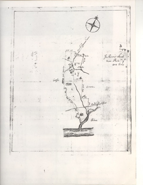
Isaac Norris' Land, 1712. Aramingo Creek / Gunner's Run is branching off the Delaware River. Norris' land is northeast of [later] Norris Street and this shows both the Sepviva and Fairhill Plantation. Norris's marvellous and well documented home at Fairhill stood near 8th & York Streets. Here, [Anthony] Palmer owns the land east of the Aramingo Creek.
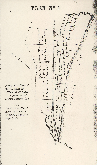
Plan of Partition of William Ball's Estate, 1755. The winding Aramingo Creek is at bottom left, the Ball estate is to the east, bounded by the Delaware River.
-----
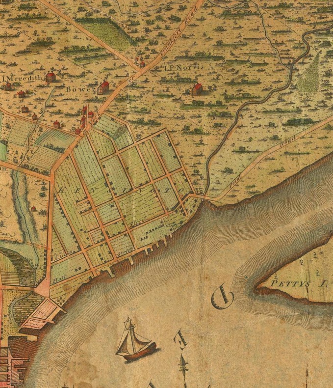
This map from 1802 shows the Aramingo Creek winds through the undeveloped land to the east of "Kensington." Note the large estate of "I.P. Norris." Detail from "Philadelphia" by Charles P. Varle, 1802. Online at www.davidrumsey.com
Detail from "Philadelphia and the commencement of the road to New York, 1802" by S.S. Moore & T.W. Jones. Published by Matthew Carey, Philadelphia. Online at www.davidrumsey.com
-----
Detail from J. C. Sidney, 1849. Note actual route of Gunner's Run and "Proposed Canal." In this case, Norris Street is just above the word "Proposed" while wider York Street terminates in the dark square. Note also the naive drawing of the "... Glass Works" at the edge of the Delaware.
-----
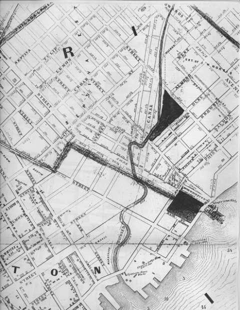
Detail from Burk & McFetridge, 1888, shows the "Aramingo Canal" waving from the Delaware River to the right. The area of excavation is near the intersection of the two widest white streets and the Aramingo Canal. Girard Avenue is parallel to the river, Norris Street is perpendicular.
-----
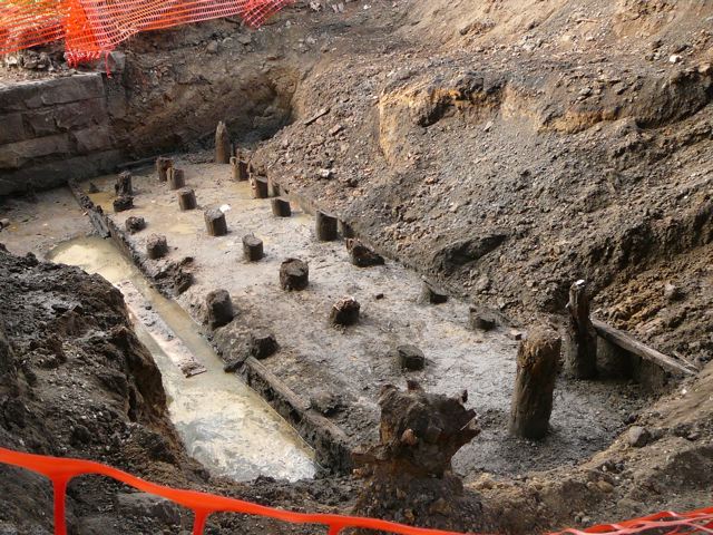
Douglas Mooney and Tony McNichol of URS dug a third hole, revealing the stone abutment (top left). This was likely for the bridge carrying Girard Avenue and Norris Street across the Aramingo Canal. Note the curious small wooden pier. This excavation is about two hundred feet northeast of the first, on the riverside of the Girard-Aramingo connector, south of the Port Richmond Shopping Center parking lot.
-----
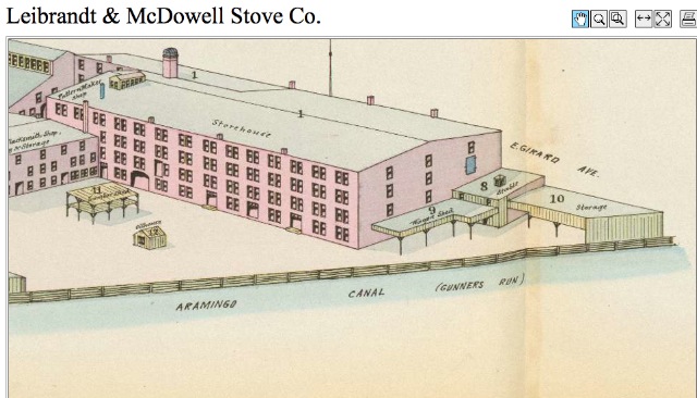
Detail from Hexamer Survey for Leibrandt & McDowell Stove Co., Girard Ash & Aramingo Canal (1879)
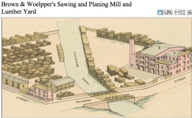
Detail from Hexamer Survey for Brown & Woelpper's Sawing & Planing Mill & Lumber Yard, Richmond Street and Aramingo Canal (1879)
-----
INFORMATION BELOW FROM GOOGLE BOOKS
http://books.google.com/books?id=KUwOAAAAIAAJ&pg=PA487&dq=aramingo+canal#PPA487,M1
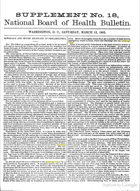
http://books.google.com/books?id=MttEAAAAMAAJ&pg=PR12&dq=aramingo+canal#PPA214,M1
http://books.google.com/books?id=mdkgAAAAIAAJ&pg=RA1-PA393&dq=aramingo+canal#PRA1-PA393,M1
http://books.google.com/books?id=Umwq-ZHEuK0C&pg=RA12-PA18-IA1&dq=aramingo+canal#PRA12-PA18-IA1,M1