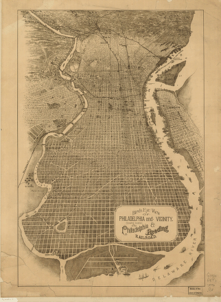
Birds eye view of Philadelphia showing location of the Philadelphia & Reading Railroad (c.1870).
An overview of South Philadelphia bounded by the Schuylkill and Delaware Rivers. League Island is at the bottom and the home of the Philadelphia Naval Ship Yard.
SOUTH PHILADELPHIA
© John Mayer,
Workshop of the
World (Oliver Evans Press, 1990).
South Philadelphia comprises
all of the city below South Street and is bounded by the
Delaware River on the east and south and by the
Schuylkill River on the west. The industrial development
of South Philadelphia has been strongly tied to the
waterfront from the earliest settlement period and later,
the rail transportation networks that emerged in the
mid-nineteenth century.
The South Philadelphia neighborhoods of Southwark,
Moyamensing and Passyunk are some of the oldest districts
of Philadelphia County, having been settled by Swedes in
the seventeenth century. 1
These districts
developed slowly along both the riverfront and early post
roads but remained sparsely settled until the mid-1800s.
South Philadelphia's sparse population and marshy areas
made it an appropriate site for slaughterhouses, leather
works, and fertilizer and chemical companies whose
noxious fumes were unwelcome in the center of the city.
The natural clay in the soil also attracted brickyards to
the area. Six of the nine brickmakers listed in McElroy's
1859 city directory were located in South Philadelphia,
primarily along Grays Ferry Road. 2
Along the
waterfront shipyards, ropewalks, and wharves spread
southward along both rivers. The Federal Street Navy
Yard, with two large ship building sheds, became one of
the most familiar landmarks in the district.
3
The introduction of steam power in the early decades of
the nineteenth-century stimulated the development of
factories through out the district. With the emergence of
railroads, Washington Avenue became a major east-west
rail connection giving South Philadelphia manufacturers
an efficient means of obtaining supplies and shipping
their products. 4
Today, large scale operations dominate the waterfront,
including the Philadelphia Naval Ship Yard, the Atlantic
Refining Company, the Schuylkill and Delaware River Power
Stations, and the Packer Avenue Terminal to name a few.
The South Philadelphia Food Distribution Center on
Pattison Avenue, built beginning in 1950, replaced the
Dock Street Market and today plays a vital role in
wholesale distribution of food for the region.
Although industry has declined dramatically in the
district, the scale of South Philadelphia's industrial
past is evident in the existing landscape. The abandoned
factories that line Washington Avenue and the few
remaining warehouses and piers along Delaware Avenue are
reminders of South Philadelphia's important place in the
industrial development of the city.
1 Joseph Jackson,
Encyclopedia
of Philadelphia, Vol. IV, (Harrisburg,
1933), pp. 1099-1100.
2 McElroy's
Philadelphia Directory, (Philadelphia, 1859), p. 809.
3 Robert
Teitelman, Birch's
Views of Philadelphia, (Philadelphia, 1982), p.
30.
4 Miller, et al,
Still
Philadelphia, (Philadelphia, 1986).
Acknowledgements:
Many thanks to
Harold E. Spaulding, who provided research data on many
of the sites in this chapter. Thanks also to Jack
Steelman, who provided insights on the Schuylkill
Generating Station. Thanks to Jeffrey Ray, who
contributed information on the Gas Works and Atlantic
Refinery, and helped with photography. Special thanks to
Dr. David Orr, who supplied research materials on the
Philadelphia Gas Works.
Resources:
South
Philadelphia